African Wildlife Poisoning Database

https://www.africanwildlifepoisoning.org/

The use of poisons to kill wildlife has a long-established place in African history. However, the rapid acceleration in this use, coupled with the move to synthetic pesticides, has been shown to have a devastating effect on populations of many species.

Poisoning is often targeted at particular species, particularly those that provide high-value by-products, but the consequences are frequently unintentional and affect any species scavenging on poisoned carcasses. This may have potentially catastrophic human health impacts, in addition to the impacts on wildlife. There is evidence that a number of different species and ecosystems are being systematically targeted.

The Vulture Specialist Group of the IUCN Species Survival Commission aims to gather and collate data on historical and current incidents of wildlife poisoning to assess the scope and impact of this threat to vultures and other scavenging birds and wildlife on the African continent. This database is designed to facilitate simple, effective loading and capture of relevant data using a webform, or a data submission template, for this purpose while ensuring that sensitive data submitted will not be shared without the consent of the submitting partner/organisation.

U.S. Fish & Wildlife Service

https://gis-fws.opendata.arcgis.com/

Our Mission: Working with others to conserve, protect and enhance fish, wildlife, plants, and their habitats for the continuing benefit of the American people.

Geospatial science, data, and technologies are vital components needed to meet the mission of the U.S. Fish and Wildlife Service

To paraphrase one of our regional geospatial coordinators, “No major conservation actions happens without geospatial technology, science, and data.” Geographic Information Systems (GIS), Global Positioning Systems (GPS), and remote sensing are the primary elements which fall under the geospatial services umbrella. Geospatial services provide the technology to create, analyze, maintain, and distribute geospatial data and information. GIS, GPS, and remote sensing play a vital role in all the Service’s long-term goals, including meeting the challenges posed by climate change. 

What have we done so far?

Geospatial technology and data are used by nearly all programs within the Service. Below are just a few examples:

  • The Midwest Fish and Aquatic Conservation Program modernized their environmental DNA work by leveraging web-based geospatial tools, leading to an estimated cost savings of $130,000 per year while also improving data quality and availability and advancing the science of conservation.
  • The National Wetland Inventory (NWI) monitors the extent and status of wetlands for management, research, policy development, education, and planning. 
  • Evaluate, plan, and implement Strategic Habitat Conservation and adaptive management at the landscape level. 
  • Conduct biological surveys and manage data including inventory monitoring, invasive species control, and Habitat Management Plans. 
  • Map realty transactions and land status of FWS managed lands and proposed expansions. 
  • Propose, designate, and inform the public about critical habitat for threatened & endangered (T&E) species and deliver official species lists and Section 7 consultations. 
  • Modernize migratory bird surveys by leveraging artificial intelligence to automatically identify and count the occurrence of birds in aerial imagery. 

Where We’re Going

Our hope is to share the incredible work taking place within US Fish and Wildlife. To that end, our hope is to share all of our public data and make it FAIR (Findable, Accessible, Interoperable, and Readable). This site will be updated with the latest Maps, Apps, and Data that are relevant to the Mission of the Service and the people we serve.  

CITES Wildlife TradeView

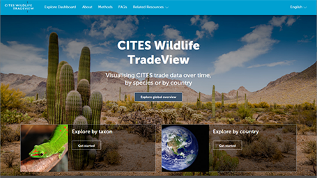
https://tradeview.cites.org/

A new, interactive, online tool for visualising data and trends in the international trade in endangered species is being launched today. CITES Wildlife TradeView is a joint project between the Secretariat of the Convention on International Trade in Endangered Species of Wild Fauna and Flora (CITES) and the UN Environment Programme World Conservation Monitoring Centre (UNEP-WCMC). It is available in English, French and Spanish.

he purpose of CITES Wildlife TradeView is to provide users with an accessible window into the world of CITES trade data and to showcase the main trading countries, species, commodities, sources and trends over time. The platform will bolster transparency and help achieve a broader understanding of the international trade in CITES-listed wildlife. 

CITES Wildlife TradeView is dynamically linked with the CITES Trade Database, a key resource for monitoring trade in the species listed in the Convention’s Appendices. This means the new platform will show the latest information as new data is uploaded into the Database.

The CITES Trade Database contains the official data provided by all Parties to the Convention in their mandatory annual reports. It currently includes over 23 million records gathered from these reports since CITES entered into force in 1975. 

The Database will remain the official location where CITES trade data will be stored and accessed, while the purpose of CITES Wildlife TradeView is to quickly visualise specific aspects of its data, which can be used for obtaining an overview that can be showcased in presentations or communication activities. 

The platform provides three tailored dashboards, enabling users to visualise trends in international wildlife trade in the following ways:

  • Global overview: providing a high-level overview of global trade in CITES-listed species
  • Country view: exploring the CITES trade for one or more countries
  • Taxon view: exploring the CITES trade data for one or more species or taxonomic groups (e.g. by searching ‘Grey Parrot’ or looking at all birds)

Kelly Malsch, Head of Nature Conserved at UNEP-WCMC, said: “The CITES Wildlife TradeView platform will help make CITES trade data more accessible and easier to grasp, even if you are not a data expert. This will, in turn, help monitor, analyse, and communicate this important dataset on the international trade in wildlife, supporting global conservation efforts.” 

Sofie Flensborg, Officer-in-Charge of the CITES Secretariat’s Outreach and Projects Unit, said: “With the launch of the CITES Wildlife TradeView, the capacity for monitoring the trade in CITES-listed species has just taken a leap forward. This is particularly important, not just in the context of CITES implementation, but also for wider global commitments to safeguard biodiversity. As we work to tackle the global biodiversity crisis, CITES Wildlife TradeView will play a crucial role in bringing important biodiversity data to light and ensuring that wildlife trade is legal and sustainable. We are grateful to UNEP-WCMC for their effort in making this user-friendly interface.

The development of this new wildlife trade visualisation platform was made possible through the financial support from the UK Research and Innovation’s Global Challenges Research Fund under the TRADE Hub project.

PACIFIC DATA HUB

https://pacificdata.org

The Pacific Data Hub (PDH), is a central repository of data about the Pacific and from the Pacific. The platform serves as a gateway to the most comprehensive collection of data and information about the Pacific across key areas including population statistics, fisheries science, climate change adaptation, disaster risk reduction and resilience, public health surveillance, conservation of plant genetic resources for food security and human rights.

The Pacific Data Hub is an innovative programme of work, led by the Pacific Community (SPC) and supported by the New Zealand Ministry of Foreign Affairs and Trade. The PDH serves as a regional public good that provides a single authoritative point of entry for data about the Pacific and serves as a vehicle for investment in a sustainable data infrastructure for the Pacific region.

We have built the PDH platform on our intimate understanding of the Pacific region and the enduring relationships we have forged with our members. We understand the policy and development challenges that matter to our members and we work in coordination with our development partners to not only provide quality data and evidence but also develop tools and capabilities that can inspire new insights, inform good decision-making and deliver improved development outcomes.

The PDH is part of an emerging Pacific Data Ecosystem, a partnership between Pacific Island Countries and Territories, SPC and the Secretariat of the Pacific Regional Environment Programme (SPREP) to promote greater coordination in data management, dissemination and uptake initiatives. We work closely with our members and our development partners to strengthen data management capabilities, develop capacity and improve data literacy within the Pacific region, ensuring that the data resources of our members and partners are well-managed, shared responsibly and used ethically.

We are keen to hear from you:

  • to understand how you are using the Pacific Data Hub,
  • if you would like to contribute to our data catalogue
  • or if you would like to explore opportunities for collaboration and partnership.

For more information, please contact us at datahub@spc.int.

Systema Naturae

https://www.systemanaturae.org/

Systema Naturae is a web platform and we index research Datasets and Conservation Projects on Wildlife . We believe in Open data and the Datasets in our website are either submitted by people from across the world or indexed by our web crawler which searches the internet actively for research Datasets and Projects.

The centralization of Datasets and Projects on wildlife will help researchers, students and policy makers get access to them as well as create awareness about the conservation efforts. 

Our Mission is to save wildlife by creating awareness with the help of publicly available Datasets and Projects. Systema Naturae addresses the gap that exists between people who produce and consume the Datasets and also people who engage in conservation Projects.

We are proud of the impact we have had so far and we are fully volunteer run.  We are one of the very few portals across the internet dedicated to wildlife research Datasets and Projects, One of the Largest Indeed!

GBIF | Global Biodiversity Information Facility

https://www.gbif.org

GBIF—the Global Biodiversity Information Facility—is an international network and data infrastructure funded by the world’s governments and aimed at providing anyone, anywhere, open access to data about all types of life on Earth.

Coordinated through its Secretariat in Copenhagen, the GBIF network of participating countries and organizations, working through participant nodes, provides data-holding institutions around the world with common standards, best practices and open-source tools enabling them to share information about where and when species have been recorded. This knowledge derives from many sources, including everything from museum specimens collected in the 18th and 19th century to geotagged smartphone photos shared by amateur naturalists in recent days and weeks.

The GBIF network draws all these sources together through the use of data standards, including Darwin Core, which forms the basis for the bulk of GBIF.org’s index of hundreds of millions of species occurrence records. Publishers provide open access to their datasets using machine-readable Creative Commons licence designations, allowing scientists, researchers and others to apply the data in about four peer-reviewed publications (along with more policy papers) every day. Many of these analyses—which cover topics from the impacts of climate change and the spread of invasive and alien pests to priorities for conservation, food security and human health—would not be possible without the data provided by the GBIF network.

The GBIF Secretariat prepares an annual work programme within a five-year strategic framework that receives review and approval of the GBIF Governing Board.

Vision

A world in which the best possible biodiversity data underpins research, policy and decisions.

Mission

To mobilize the data, skills and technologies needed to make comprehensive biodiversity information freely available for science and decisions addressing biodiversity loss and sustainable development.

European Data Portal

https://www.europeandataportal.eu/data/datasets?locale=en&query=wildlife&page=1

European Data Portal

The European Data Portal harvests the metadata of Public Sector Information available on public data portals across European countries. Information regarding the provision of data and the benefits of re-using data is also included.

About the European Data Portal

Going beyond the harvesting of metadata, the strategic objective of the European Data Portal is to improve accessibility and increase the value of Open Data:

  • Accessibility: How to access this information? Where to find it? How to make it available in the first place? In domains, across domains, across countries? In what language?
  • Value: For what purpose and what economic gain? Societal gain? Democratic gain? In what format? What is the critical mass?

The European Data Portal addresses the whole data value chain: from data publishing to data re-use.

Within the Portal, sections are dedicated to:

Searching datasets: Categories have been established to structure the metadata harvested from the various countries. These categories follow the revision of the DCAT Application Profile and have been mapped against the Eurovoc Thesaurus.

Providing Data: This section gives an insight into understanding Open Data from the perspective of a data provider. In addition, instructions are offered for those who wish their data portal to be harvested by the European Data Portal.

Using Data: How Open Data is being used, as well as the economic benefits of Open Data are detailed in this section.

Training and Library: eLearning modules about Open Data as well as training guides and a knowledge base referencing publications around Open Data and featured projects.

Portals can be national, regional, local or domain specific. We connect portals in the EU Member States, the European Economic Area (EEA), the European Free Trade Area (EFTA), the EU accession countries, and countries involved in the EU’s neighbourhood policy. In addition, by harvesting the European Union Open Data Portal, we also cover European institutions, agencies and bodies and some cross-border content from EU-funded projects.

Discover how to use the portal

The European Data Portal harvests the metadata of public data made available across Europe. The data catalogues of origin may contain datasets with errors.

The Portal will assess these errors and communicate them back to the owners of the catalogues. This will contribute to improving the quality of the metadata and data available throughout Europe. This Portal is developed by the European Commission with the support of a consortium led by Capgemini Invent, including INTRASOFT International, Fraunhofer Fokus, con terra, Sogeti, the University of Southampton, Time.Lex, 52 North and the Lisbon Council.

For specific queries please click the following link.

The specific scope of Open Data used within the European Data Portal is data published by public administrations or on their behalf.

The metadata contains the information made available with the data set by the initial publisher. Different licences, or absence of licence may occur and re-uses are invited to check with the owners/publishers of the data what terms and conditions apply to the re-use of the data.

OBIS

https://obis.org/

VISION To be the most comprehensive gateway to the world’s ocean biodiversity and biogeographic data and information required to address pressing coastal and world ocean concerns.

MISSION To build and maintain a global alliance that collaborates with scientific communities to facilitate free and open access to, and application of, biodiversity and biogeographic data and information on marine life.

More than 20 OBIS nodes around the world connect 500 institutions from 56 countries. Collectively, they have provided over 45 million observations of nearly 120 000 marine species, from Bacteria to Whales, from the surface to 10 900 meters depth, and from the Tropics to the Poles. The datasets are integrated so you can search and map them all seamlessly by species name, higher taxonomic level, geographic area, depth, time and environmental parameters. OBIS emanates from the Census of Marine Life (2000-2010) and was adopted as a project under IOC-UNESCO’s International Oceanographic Data and Information (IODE) programme in 2009.

Objectives

  • Provide world’s largest scientific knowledge base on the diversity, distribution and abundance of all marine organisms in an integrated and standardized format (as a contribution to Aichi biodiversity target 19)
  • Facilitate the integration of biogeographic information with physical and chemical environmental data, to facilitate climate change studies
  • Contribute to a concerted global approach to marine biodiversity and ecosystem monitoring, through guidelines on standards and best practices, including globally agreed Essential Ocean Variables, observing plans, and indicators in collaboration with other IOC programs
  • Support the assessment of the state of marine biological diversity to better inform policy makers, and respond to the needs of regional and global processes such as the UN World Ocean Assessment (WOA) and the Intergovernmental Science-Policy Platform on Biodiversity and Ecosystem Services (IPBES)
  • Provide data, information and tools to support the identification of biologically important marine and coastal habitats for the development of marine spatial plans and other area-based management plans (e.g. for the identification of Ecologically or Biologically Significant marine Areas (EBSAs) under the Convention on Biological Diversity.
  • Increase the institutional and professional capacity in marine biodiversity and ecosystem data collection, management, analysis and reporting tools, as part of IOC’s Ocean Teacher Global Academy (OTGA)
  • Provide information and guidance on the use of biodiversity data for education and research and provide state of the art services to society including decision makers
  • Provide a global platform for international collaboration between national and regional marine biodiversity and ecosystem monitoring programmes, enhancing Member States and global contributions to inter alia, the Global Ocean Observing System (GOOS) and the Global Earth Observing System of Systems (GEOSS)

Whale Shark Tracker

https://www.conservation.org/projects/whale-shark-tracker

In 2015, Conservation International scientists in Indonesia performed a first: We attached satellite transmitters to the dorsal fins of whale sharks. These transmitters had never been mounted on whale sharks because the species was simply too big to catch — so our scientists partnered with local fishermen who had inadvertently captured whale sharks in their nets, then dived in to attach the transmitters before releasing the sharks. Working with our partners at the Georgia Aquarium, we’ve learned a lot about the charismatic species, including their migratory movements and diving behavior — much of it new to science.​​

KORA

https://www.kora.ch

In this centre current as well as previous data for lynx, wolf and bear distributioThe return of the large carnivores to our country is the last phase of the rescue of our native wildlife whose populations reached a historical low point in the 19th century due to uncontrolled overexploitation and habitat destruction. Lynx, wolves and bears are not returning to a wilderness but into a landscape dominated by heavy human use with the many diverse needs of different users; this may trigger conflicts.

KORA studies the life history of the carnivores and monitors the development of their populations. We explore the effect of carnivores in our modern cultural landscape and use this baseline information in the process of minimizing conflicts under the coexistence of large carnivores and people.